


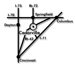
Cedarville is located in the middle of a triangle formed by Interstates 70, 71, and 75.
From the North
I-75 south to I-70 east; travel approximately 24 miles to the Springfield/Cedarville exit (Rt. 72); travel south 11 miles on Rt. 72 to the campus. (Approximately 38 minutes from downtown Dayton.)
From the South
I-75 north to Cincinnati; merge with I-71; take I-71 north to the Sabina/Jamestown exit 58 (Rt. 72); follow Rt. 72 north to Cedarville. Proceed through Cedarville three blocks to the campus. (Approximately 1 hour 17 minutes from downtown Cincinnati.)
From the East
I-70 west to the Cedarville/Springfield exit 54 (Rt. 72); travel south 11 miles on Rt. 72 to the campus. (Approximately one hour from downtown Columbus.)
From the West
I-70 east to the Cedarville/Springfield exit 54 (Rt. 72); travel south 11 miles on Rt. 72 to the campus.
From US-35
US-35 through Xenia; Rt. 42 (north) to 72 (north), which is Main Street. Proceed through Cedarville three blocks to the campus.
Traveling by Air
Cedarville University is located in southwestern Ohio with easy interstate highway access from three international airports. The nearest commercial airport is Dayton International Airport (DAY), a 35-minute drive from Cedarville's campus. The John Glenn Columbus International Airport (CMH) is 65 minutes, and the Cincinnati/Northern Kentucky International Airport (CVG) is 85 minutes from campus.